
Biking is a favorite activity for both locals and visitors here in Gulf Shores and Orange Beach all year long. The Alabama Gulf Coast offers plenty of amazing trails and paths for bikers to explore the area and get around. Whether you're looking for a nice ride to the beach or a lengthy trek in the park, there's a trail for you to enjoy.
Beach Cruisin'
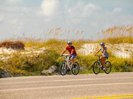
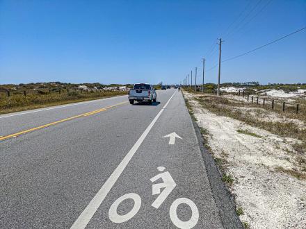
1. Alabama's Coastal Connection
Distance: 4 miles, round trip
Difficulty: Easy
This ride along the beautiful sugar-white beaches and turquoise waters of the Gulf of Mexico offers an excellent view of the beach. The route uses a section of the wide bike lane of Highway 182 between the Gulf State Park Pier and the Rosemary Dunes Trailhead, passing the unique architecture of the Gulf State Park Beach Pavilion. You can start at either the pier or the Rosemary Dunes Trailhead. The advantage of starting at the Rosemary Dunes Trailhead is that Beach Bike Rentals is right there, so you don't even have to bring a bike.

2. Gulf Place
Difficulty: Easy
The convenient sidewalks along Perdido Beach Blvd. in Gulf Shores allow riders to cruise right along the beach. Gulf Place Public Beach has paved walkways surrounding its grassy lawn and playground, making it a great spot for young children to pedal around. Once you're finished with your ride, grab a bite to eat at one of the fantastic restaurants in the area or take a dip into the Gulf.
Recreational

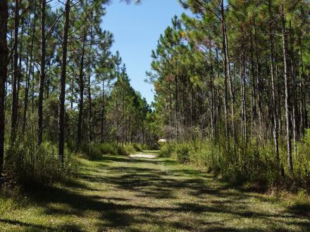
3. Hugh S. Branyon Backcountry Trail
Distance: Over 28 miles of trail options
Difficulty: Easy to moderate (if you do a long trip)
Winding through the "backcountry" of Gulf State Park is the Hugh S. Branyon Backcountry Trail, a series of eight paved multi-use trails of varying lengths that travel through nine different ecosystems. This trail provides a fantastic ride through longleaf pine forests, past shimmering freshwater lakes, coastal wetlands, and marshes. And you never know what animals you may see, such as white-tailed deer, coyotes, bobcats, and even alligators, that can be spotted on the trail. The paths give you many options for long and short trips and are perfect for families and experienced road bikers. There are a few minor hills to contend with, but nothing severe. The trail has six restrooms and two water fountains either on the trail or just off it. A favorite mid-level trip is a three-mile loop beginning at the Orange Beach Sportsplex on the Twin Bridges Trail to the Power Connector Trail, Rosemary Dunes, Catman Road, and back to the trailhead on the Twin Bridges.

4. Fort Morgan Road Trail
Distance: 10.8 miles, round trip
Difficulty: Moderate
The Fort Morgan Road Trail is a pleasant pedal from the intersection of Alabama Highway 59 and Hwy.180 at the Rouses Shopping Center to Peninsula Golf and Racket Club, 5.4 miles (one way). Before heading off, be sure to fill up on some delicious beignets and coffee at Café Beignets, located at the starting point. From the shopping center, the trail is a wide, multi-use path that parallels Highway 180, but most of the trip is well off the road behind a barrier of trees. The trail is ideal for families since it is a paved, level track, but a round-trip with children could be challenging due to the length. You may consider doing a short segment with them.
Off-Road
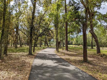
5. Graham Creek Nature Preserve
Distance: Up to 10 miles
Difficulty: Easy to moderate
Graham Creek Nature Preserve is the best off-road mountain biking trail in the area. It has more than 10 miles of trails, and while not as technically challenging as racing around a mountain, Graham Creek presents its own challenges, mostly involving water. You'll find two stream crossings and several areas that are low-lying swales. They fill with water after rain and present some good mud-running as they dry out. Otherwise, the trails are wide, grassy paths.
For Roadies
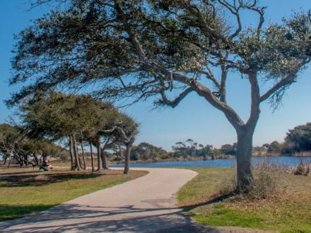
6. Lake Shelby Loop
Distance: 6 miles
Difficulty: Moderate
This paved biking path makes a loop in Gulf State Park and uses the bike lanes of Highway 135, State Park Road 2, and Highway 182 to navigate around Lake Shelby. The loop offers beautiful views of the lake and its wetlands. During your ride, keep your eyes peeled for birds like bald eagles, osprey, and hawks that nest in the park!
7. Fort Morgan Road West
Distance: 24 miles, round trip
Difficulty: Moderate to difficult due to distance
Advanced riders should check out Fort Morgan Road West. The bike path starts at the Bon Secour National Wildlife Refuge's Pine Beach Trailhead on Highway 180 and heads west using bike lanes for 12 miles to Historic Fort Morgan. The fort is famous for being the site of the Battle of Mobile Bay during the Civil War, in which Union Admiral David Farragut uttered those immortal words, "Damn the torpedoes, full speed ahead!" Be mindful of traffic, especially on the first few miles of this ride. The lane is narrow around bends, but it widens and gives you spectacular views of Mobile Bay to the north and the Gulf to the south as you bike along between the sand dunes.
Long Distance
8. Alabama to Florida
Distance: 27.4 miles, round trip
Difficulty: Difficult due to distance
This trek is a favorite route for long-distance road bikers. It begins at the Public Beach parking area at the end of Highway 59 in Gulf Shores and follows the shoreline along Highway 182 to Perdido Beach State Park in Florida, a trip of 13.7 miles one way. The ride takes you past beautiful white beaches, dunes, and turquoise Gulf waters. Just before crossing into Florida, you'll pass the world-famous Flora-Bama Lounge & Oyster Bar. Celebrate finishing your ride with a creamy bushwacker!
Originally written by RootsRated for Gulf Shores, AL
Ready to go for a ride along Alabama's beaches? Be sure to take a look at all the biking routes and rentals in the area. We hope to see you on the trails!